
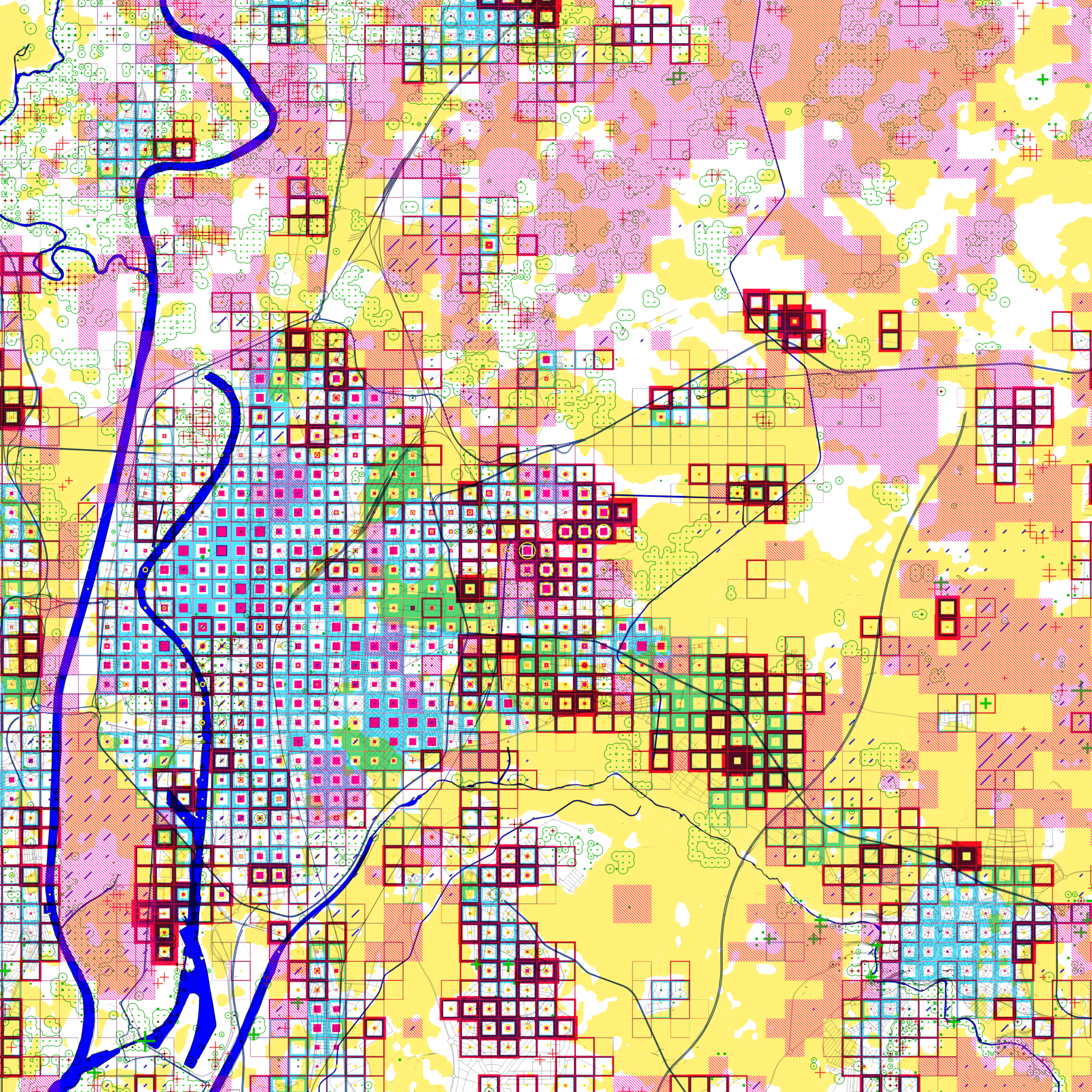
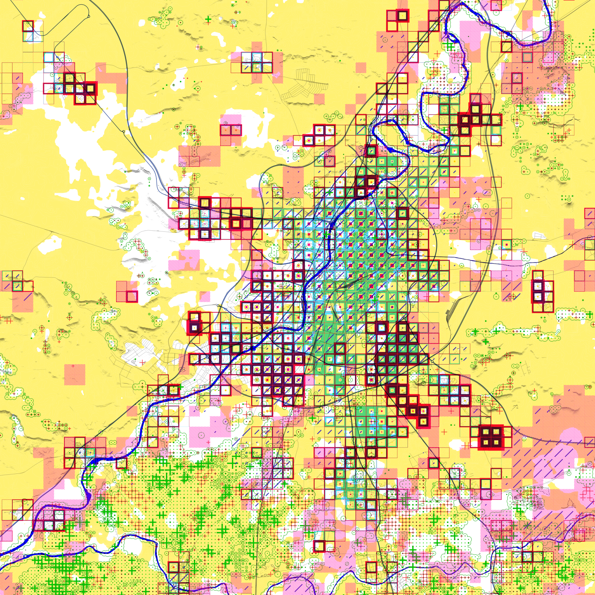
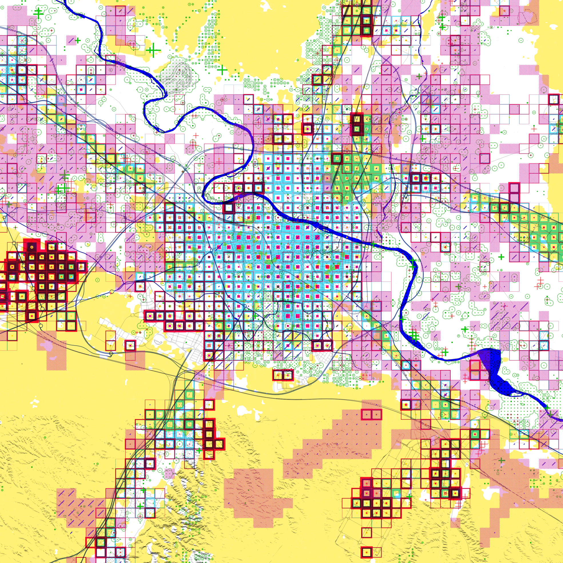
The following maps show the urban and demographic expansion of some Spanish cities over the last 45 years, thanks to data generated by the Global Human Settlement Layer. By re-analyzing satellite images captured by the Sentinel and Landsat networks, the layer infers the urban land cover and the distribution of the population over it.
In this way, it is possible to compare land use depletion for a period of time ranging from 2020 (when we have structured and accurate data sources for a description of the territory) to 1975, when these sources either did not exist or were scarce and much less accurate. Along with this information, the variation in vegetation coverage by the Global Land Analysis and Discovery for the period between 2000 and 2021 is also attached, which also shows the loss and gain of forest masses.
Thus, these maps show the current state of the urbanization of the territory and its occupation by the population that inhabits it, while also explaining its variation over time, together with the territory and the natural environment that supports it.
While the past and present are the key to this description, some of the challenges that will shape its future are also shown. To this end, on the one hand, the quality of the built-up area registered by the National Cadastre Office is incorporated (showing those areas with precarious buildings), and on the other hand, the concentration of heat during a typical day last summer recorded with the Landsat 8 satellite (values above the median).
The information displayed is aggregated on a 339-meter grid, a multiple of the 113 meters that define the inter-axis of the Eixample district in Barcelona, which allows the combination of different data sources through the overlap of colors.
Thanks to the current new data scenario, we can construct a narrative of our cities with higher temporal and spatial resolution, under the same view that allows us to compare them. Making the continuous territory, also continuous with the data. From this reading, the first evidence of the change of model emerges: moving from a city consuming its territory towards new paradigms of a city in balance with the environment and (possible) degrowth.
Las siguientes cartografías muestran la expansión urbana y demográfica de algunas ciudades españolas a lo largo de los últimos 45 años gracias a los datos generados por el Global Human Settlement Layer que, mediante el reanálisis de de las imágenes de satélite, capturadas por la red Sentinel y Landsat, infiere la cobertura urbanizada del suelo así como la distribución de la población sobre éste.
De este modo, es posible obtener una comparación del agotamiento del suelo para un periodo de tiempo que va desde el 2020 (en el que disponemos de fuentes de datos estructuradas y precisas para una descripción del territorio) hasta el 1975, cuando estas fuentes no existían o bien eran escasas y de mucha menor precisión. Junto a estas informaciones se adjunta también la variación de la cobertura vegetal realizada por el Global Land Analysis and Discovery para un periodo comprendido entre el 2000 y el 2021 que muestra además la pérdida y la ganancia de masas boscosas.
Así, estos mapas muestran el estado actual de la urbanización del territorio y su ocupación por aquella población que lo habita; a la vez que explica también su variación a lo largo del tiempo, junto al territorio y el entorno natural que lo soporta.
Si bien pasado y presente son la clave de esta descripción también se quiere mostrar algunos de los retos que configurarán su futuro. Para ello, por un lado, se incorpora la calidad del parque edificado registrado por la Sede Nacional del Catastro (en el que se muestran aquellos ámbitos con edificaciones precarias) y, por otro, la concentración del calor durante un día típico del pasado verano registrado con el satélite Landsat 8 (valores superiores a la mediana).
La información mostrada está agregada sobre una rejilla de 339 metros, múltiple de los 113 metros que definen el intereje del Eixample de Barcelona, que permite la combinación de distintas fuentes de datos mediante la superposición de los colores.
Gracias al nuevo escenario de datos actual, podemos construir un relato de nuestras ciudades con mayor resolución temporal y espacial, bajo una misma mirada que nos permite compararlas. Haciendo que el territorio contínuo, lo sea también con los datos. De esta lectura, emergen las primeras evidencias del cambio de modelo: transitando desde una urbanidad consumidora de su territorio hacia nuevos paradigmas de ciudad en equilibrio con el entorno y (posible) decrecimiento.
Images


Promoters
