The Affordable Housing Atlas aims to look into the issue of housing access on a global scale. The approach to the issue is supported by data provided by multiple sources, making it possible to describe the planet on a global scale using the criteria of the Affordable Housing Activation (AHA) scientific committee, which has defined different barriers contributing to housing inaccessibility.
In the framework of the UIA 2022 International Forum "Affordable Housing Activation: Removing Barriers", the Consejo Superior de los Colegios de Arquitectos de España (CSCAE) has launched a useful tool developed by 300.000 km/s: the first dynamic atlas on access to housing. This atlas brings together on a single platform more than 4,000 financial, urban context and development indicators from the main international organisations, from official and non-structured sources, making it easy to understand, read and interpret. These organisations include, for example, the World Bank, the Ibero-American Development Bank, the International Monetary Fund, and the World Health Organisation, among others.
Topics
How technology transforms urban planning and governance?
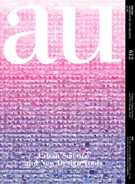
This September issue of A+U is devoted to new technologies in urban science and their applications in settings that range from the aesthetics of urban spaces to participatory democracy and public health. Edited by Yuji Yoshimura, It includes some of the projects developed by 300.000 Km/s such as Mercè, Geographies of the Lockdown, Nocturnal Landscapes, Ciutat Vella Land-Use Plan and Air/Aria/Aire -that explore how these technologies will change the ways in which architects shape urban spaces.
These and other projects from Barcelona, which has been at the forefront of using these new tools at the municipal level, are presented alongside recent efforts in the United States and Japan, covering not only “the physical aspects of cities”, but also “the systems and public-private platforms that have made them possible, and how cities can consider the issue of privacy.” We discover how information can be gathered, visualized, and used as a communication and design tool to plan a livable city, often with the government and citizens in partnership.
“(…) Precisely, this same public space that has been one of the vectors of Barcelona’s transformation (also from the economic point of view as it has generated capital gains) become inaccessible during Covid-19 lockdown in 2020. The sudden lack of public space reduced the health environments of many citizens to tiny, poor quality and highly saturated homes -depicted in the cartographies Geographies of the lockdown. This pandemic scenario revealed how that common thing, with which we have endowed ourselves with services and value, was not yet a right. Public space, as a separate environment to the domestic space, was not recognized. Again, this situation puts Barcelona’s urban model in crisis: a paradigm where urban growth is based on the construction of a common space which citizens have not had the right to use when they most needed it.
From nocturnal landscape, noise-based regulation or air pollution consequences to defining liveability, our practice focuses on the dichotomy between form and behaviour, sustaining a long tradition of city observation and representation with casual data as a new means of expression and thinking. “
Related links
linkhttps://au-magazine.com/shop/architecture-and-urbanism/au-202109/
Related projects
Exploring global metropolis at night
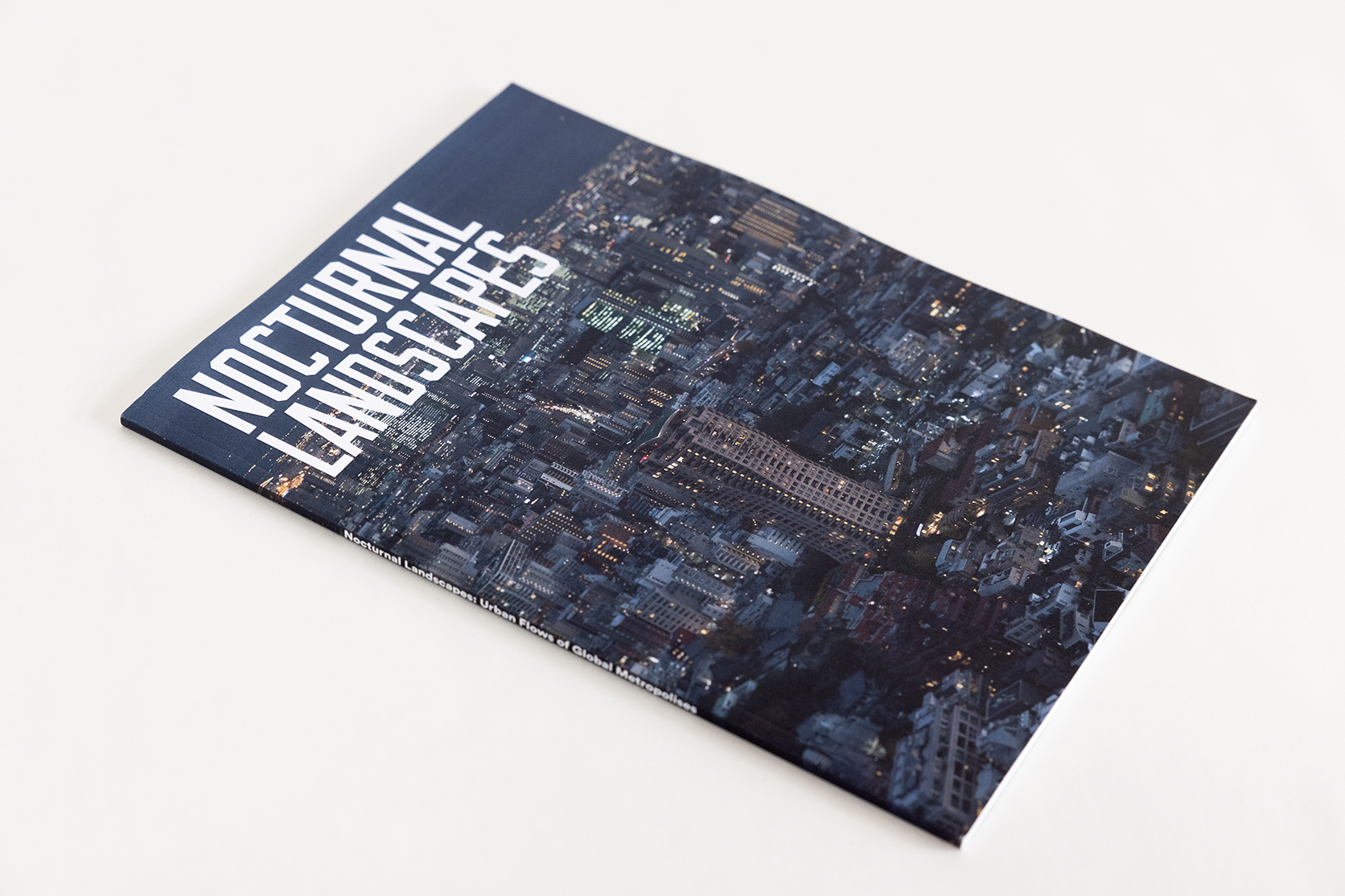
The research carried out in the project Nocturnal Landscapes: Urban Flows of Global Metropolises, curated by Iker Gil and organized by MAS Context, has materialized in a publication that collects the contents of the project’s exhibition in Chicago as well as new ones.
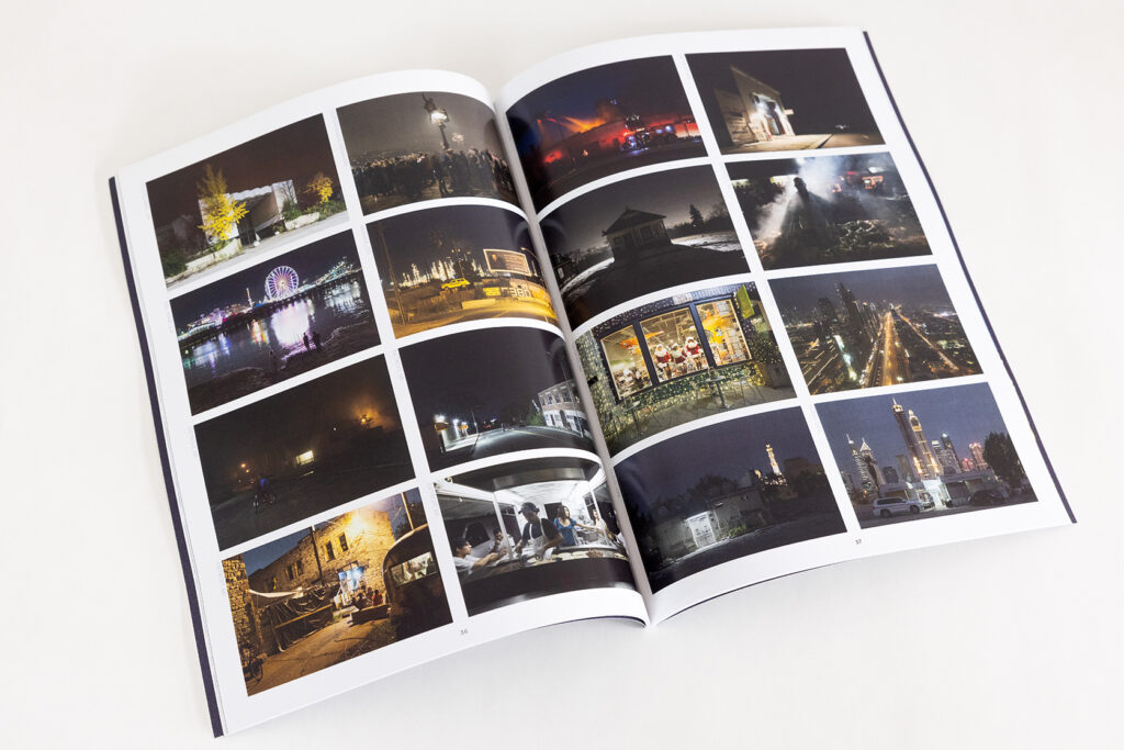
Nocturnal Landscapes: Urban Flows of Global Metropolises is a project that observes and analyzes cities at night from an interdisciplinary perspective. We have used data about urban life to compare the rhythms and regions of global cities through cartographic representations. The maps and graphics generated are complemented by the photographs of David Schalliol, photographer and sociologist, questioning the correlation of human activity and light, and revealing hidden aspects of our cities.
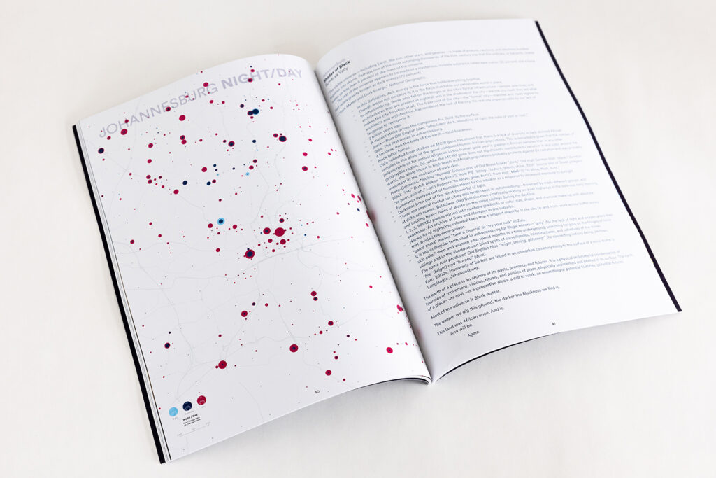
The large and continuous urban extensions, which characterize the world’s largest metropolises, become isolated fragments of light. These spots result from citizens’ activities. At the same time, they reveal places of collective symbolism (where monuments or large streets are profusely lit) and the areas where economic power is present through illuminated buildings and bright signs, conspicuous landmarks in the nocturnal landscape.
The project’s nighttime geographies are not only maps of light but also cartographies of darkness. Diagrams describe the shape of the city, how it is used, and who governs it. Drawings emphasize that darkness is more meaningful than light itself. If light embodies resence of activity, darkness denotes a noisy absence that requires further examination.
Aiming at rendering this duality visible, these cartographic series explore the relationship between citizens’ activity and urban lighting. On the one hand, we use massive data from Google platforms informing us of the percentage of the total capacity of each business located in the city (every day and every hour of the week). On the other hand, we also work with photographs taken by astronauts with their own cameras from the International Space Station. These images provide a level of detail not possible to obtain by current public satellites (Landsat and Sentinel). These cartographies describing our world were unimaginable only a few years ago. Today, they are a reality thanks to published data
available to everyone.
Images
Related projects
Topics
Making air pollution visible
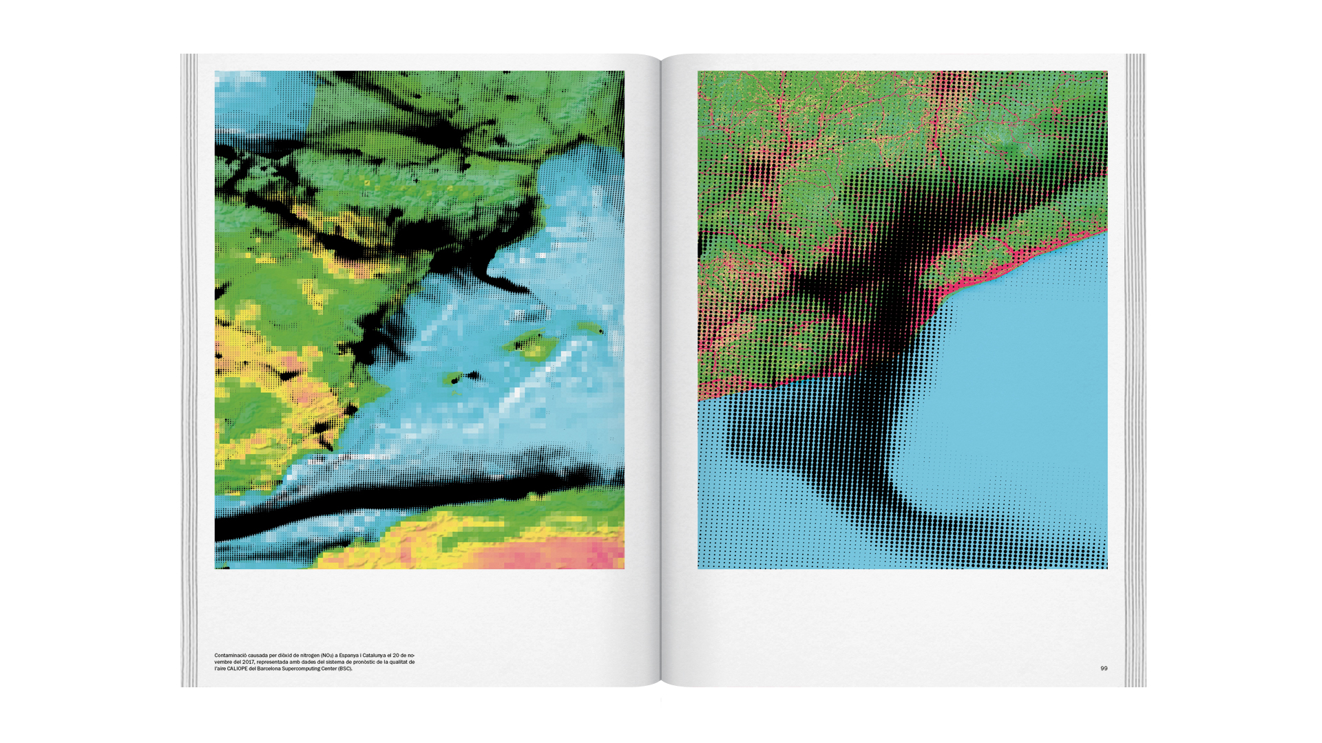
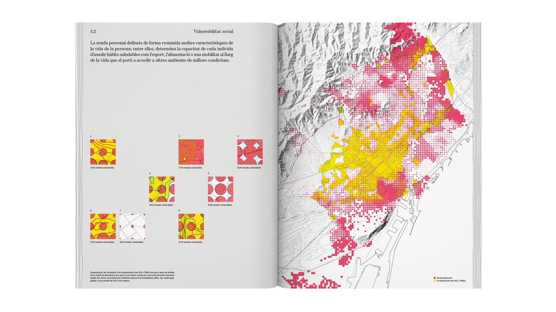
A special edition of the COAC magazine Quaderns d’Arquitectura i Urbanisme, dedicated to the project “Catalonia in Venice – Air / Aria / Aire” has recently been published.
The monograph, directed by the architect Olga Subirós, collects the research carried out for the project as well as articles written especially for the magazine.

The Generalitat’s pollution measurement station in Begur records one ofCatalonia’s highest levels of ozone, a pollutant that causes various diseases,including asthma. Begur is a town located on the coast (Baix Empordà), with a small population, low density and few cars. The origin of this ozone(O 3) is the transformation of nitrogen dioxide (NO 2) in its displacement from Barcelona. Barcelona and its metropolitan region contain some of the highest built densities in all of Europe. It is a hub of mobility, attraction and vehicle emissions. The density of population, but also of economic activities and the traffic they generate, causes unhealthy levels of pollution both in the cities themselves and on the outskirts, which do not remain unaffected.The NO 2 generated in the towns and cities of the metropolitan region, af-fected by the action of the sun and the atmosphere, evolves into O3 when it travels across the territory and invades it. The concentration of urbanity in the metropolitan region of Barcelona therefore creates problems there and in the rest of Catalan territory.
Related links
linkhttp://air.300000.eu/
Images
Related projects
Topics
This catalog consists of three volumes that collect and expand on the contents of the Metròpolis Barcelona exhibition that analyzes the situation of metropolitan Barcelona, with the aim of mainly understanding how it has been formed and transformed in the last forty years.
The first volume "Metropolitan urbanism today" collects the contents of the exhibition and provides the contribution of some twenty international experts. The second volume "Metropolitan Transformations" includes the itinerary of the recent transformation of metropolitan Barcelona and points to the opportunities that may open up with the new PDU. The catalog also includes a 150-page Atlas that brings together a total of 70 cartographies and graphics.
Related links
linkhttp://www3.amb.cat/repositori/PDU/Cat%C3%A0leg%20Metr%C3%B2polis%201.pdf
linkhttp://www3.amb.cat/repositori/PDU/Cat%C3%A0leg%20Metr%C3%B2polis%202.pdf
Promoters

Areas Metropolitana de Barcelona
A citizen science experiment: citizens training algorithms to do more livable urban environments
The report compiles the results of the Mercè project, a citizen science experiment carried out from May to November 2020 in which citizens have trained an artificial intelligence algorithm to be able to predict the habitability of the city of Barcelona. The report collects the main results of the experiment and determines which are the most and least livable streets in the city based on variables that have been individualized thanks to the vote of the citizens.
Related links
linkhttp://merce.300000.eu/data2/informe_merce.pdf
Related projects
Integrated urban planning, learning from Europe
Our contribution to the book ‘Integrated urban planning: learning from Europe’ promoted by Diputació de Barcelona and edited by Paisaje Transversal is a compendium of best practices under the title ‘We cannot work with what we cannot measure”.
The article aims at helping institutions to implement integrated urban planning in line with Europe and the major global agendas using a series of own experiences (Energy map of Rubí, Open Papers and Arturo) to present the toolkit available to public administrations today interested in incorporating the new ecosystem of public data and big data into their urban policy and planning.
Related links
linkhttps://gaue.diba.cat/wp-content/uploads/2020/01/62439.pdf
Toward Citizen Producers of Data
This article focuses on the existence of a possible data divide in the context of growing digitalization. The Open Papers project helps shine a light on social inequality derived from an inaccurate datafication of the environment. What urban problems are left out of decision-making processes due to a lack of information? How can citizens generate data without using complex technologies through processes of collective capture?
Related links
linkhttp://www.laaab.es/2018/10/hacia-una-ciudadania-productora-de-datos/
Cities will belong to those who map them
The Aragonese government launched an open and collaborative platform for sharing knowledge and practices focused on the areas of open government and social innovation. Given this situation, we reflect on the need to involve the administration and citizens in the generation of data infrastructures in a context of the increasing privatization (at the hands of large corporations) of cartographic and geospatial information.
Related links
linkhttp://www.laaab.es/2019/04/las-ciudades-seran-de-quien-las-cartografie/


